


Chichen Itza Site-Emblem T-Shirt, Mexico
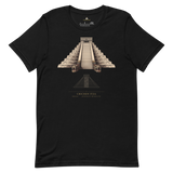
The stepped-pyramid silhouette of El Castillo with its carved serpent head at the staircase base, printed alongside the geometry diagram Pyramason actually tested against the wider Yucatan site cluster: 34 golden-ratio pairs against 29.6 expected by chance, p = 0.3178, consistent with chance. Beneath it: Chichen Itza, Mexico, 20.683056, -88.568611. Those are Pyramason's own catalogued coordinates for the staircase that grows a serpent twice a year.
- Stepped-pyramid silhouette with carved serpent head, instantly identifiable even without colour
- Geometry diagram shows Pyramason's real test result: consistent with chance, honestly labelled
- Exact coordinates (20.683056, -88.568611) printed beneath the monument and country
- Soft, pre-shrunk cotton in a minimalist gold-on-dark line-art treatment
Why this site. El Castillo is a working piece of solar architecture, still casting its equinox serpent-shadow illusion roughly 900 years after it was built. That alignment is real, dated and observable. The geometry between Chichen Itza and its neighbours is a separate question, and there our engine finds nothing beyond chance. Both statements are true at once, which is the point: a monument does not need a hidden network to be extraordinary when its own architecture already performs on schedule.
Chichen Itza · Mexico · 20°40'59.0"N 88°34'07.0"W