


Tikal Site-Emblem T-Shirt, Guatemala
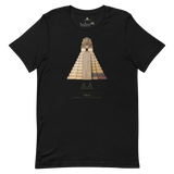
A line-art rendering of Temple IV rising above the Peten canopy, paired with the geometry diagram Pyramason actually ran across the Maya lowlands: 41 golden-ratio pairs against 42.1 expected, p = 0.5802, consistent with chance. Printed beneath: Tikal, Guatemala, 17.222094, -89.623614, from our own site record.
- Engraved-style illustration of Temple IV, the ~70m tallest pre-Columbian structure built in the Americas
- Geometry diagram shows our real test result: 41 hits where chance predicts 42
- Site name, country and true coordinates (17.222094, -89.623614) printed beneath the artwork
- 100% combed cotton, unisex sizing, screen-printed for durability
Why this site. The 2018 LiDAR survey of the Peten stripped the forest away digitally and revealed something like sixty thousand uncatalogued structures around Tikal: causeways, fortifications, terraces, whole suburbs. The Maya lowlands held millions more people than anyone allowed for. That is a genuine rewrite of the textbooks, and it happened in our lifetime. Our own geometry test lands almost exactly on chance, 41 against 42, which is about as clean a null as this test produces. The discovery that matters here came from lasers, not from ratios.
Tikal · Guatemala · 17°13'19.5"N 89°37'25.0"W