


The Emporium
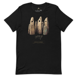
Karahunj Site-Emblem T-Shirt, Armenia
£29.99
Karahunj's stone ring, printed with the geometry actually behind its holed stones: a documented feature, not the disputed "observatory" it's often sold as. Site name, country and Pyramason's own catalogued coordinates, 39.5507° N, 46.0286° E, printed beneath the artwork. For people who'd rather wear the Bronze Age necropolis than the marketing claim.
- Engraved diagram of the holed basalt stones, documented and undisputed regardless of interpretation
- Exact coordinates (39.5507, 46.0286) printed beneath the artwork, pulled from Pyramason's own database
- Site name and country (Armenia) clearly labelled
- Soft, pre-shrunk cotton in volcanic basalt-grey and mountain-green colourways
Why this site. Karahunj carries one of the most contested claims in our whole catalogue: a national government-endorsed "world's oldest observatory" label that the excavating archaeologists themselves reject. It's exactly the kind of site Pyramason exists to report on honestly: real stones, real graves, a claim that doesn't hold up.
Zorats Karer · Armenia · 39°33'02.5"N 46°01'43.0"E
Reviews
Verified buyers, collected by Judge.me.