
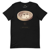


Chaco Canyon Site-Emblem T-Shirt, USA
The curved outer wall of Pueblo Bonito, Chaco Canyon's largest great house, printed alongside the geometry diagram Pyramason actually ran across the San Juan Basin: 1 golden-ratio pair against 1.8 expected, p = 0.7666, on a thin six-site sample. Beneath it: Chaco Canyon, United States, 36.063778, -107.970833, our own catalogued coordinates.
- Pueblo Bonito's curved D-shaped wall, the defining plan of the site
- Geometry diagram shows the real result with its small-sample caveat, not a confident verdict
- Exact coordinates (36.063778, -107.970833) printed beneath the monument and country
- Soft, pre-shrunk cotton in a minimalist gold-on-dark line-art treatment
Why this site. Chaco is the strongest case in the atlas for the difference between what we can test and what is actually there. Our regional geometry test finds nothing, on a sample of only six catalogued sites, which is too thin to mean much. Meanwhile Pueblo Bonito's main walls run true north-south and east-west, the Great North Road runs for dozens of kilometres on a near-perfect bearing, and the Sun Dagger on Fajada Butte marks solstices and the 18.6-year lunar standstill. Those are documented, surveyed and not in dispute. Our null says nothing against them.
Chaco Canyon · United States · 36°03'49.6"N 107°58'15.0"W